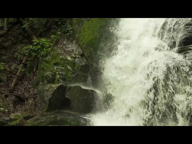
https://www.youtube.com/watch?v=NQTLh-j5MzA
Crabtree Falls is the highest vertical-drop cascading waterfall east of the Mississippi River.

This popular attraction is located in Nelson County, Virginia, just six miles off the scenic Blue Ridge Parkway near milepost 27.

Learn More
The Details

Crabtree Falls features a series of five major cascades and a number of smaller ones that fall a total distance of 1,200 feet. The first overlook is just a few hundred feet from the parking lot along a gentle, paved trail making it an excellent stopover for travelers of all ages and abilities.

The more adventuresome hiker may continue along the 3-mile trail to four other overlooks offering spectacular views of the Crabtree Creek Falls and lovely vistas of the Tye River Valley. From the upper falls, the trail follows the creek another 1.2 miles to the Crabtree Meadows. Please stay on trail – rocks are slippery.

Open dawn to dusk. Parking lot with daily parking fee per vehicle. All dogs must be leashed.

Directions
From US Route 29, take Route 56 west at Colleen.

Follow Rt. 56 for approximately 20 miles to 11581 Crabtree Falls Highway, Montebello, VA.

From the Blue Ridge Parkway (Milepost 27) take Rt. 56 east for 6.3 miles to Crabtree Falls.

Address
11581 Crabtree Falls Highway, Montebello, VA 24464
(NOTE: GPS/ Navigation devices often do not work in this area.)

Important Information

General Information

Please visit the U.S. Forest Service Glenwood Pedlar Ranger District website for current conditions.

Address11581 Crabtree Falls Highway (Rt 56), Montebello, VA 24464
Fees$3.00 Fee per vehicle per day. (Honor system / no change available)
OpenOpen Daily (dawn to dusk)
DifficultyModerate difficulty, also some stairs on trail (most overlooks during first half of hike)
RestrictionsCAUTION: Leaving the trail has resulted in numerous fatalities due to extraordinarily slippery conditions created by clear algae on rocks. Hikers must STAY ON THE TRAIL and pets must be leashed at all times. Alcoholic beverages prohibited. No horses or bicycles allowed.
Water Volume (Avg)50 cubic feet of water per second, and eventually flows into the Tye River
Closest TownMontebello, VA
WaterNo drinking water available (bring water & food with you)
Hiking PrepWear appropriate footwear/hiking shoes or other. (Opt. hiking poles)
RestroomsVault toilets at parking lot.(Vault toilets at Crabtree Meadows (at top) are open mid-March thru end of November.
Other AmenitiesPicnic table(s) located near the footbridge across the parking lot.
Operated ByGlenwood and Pedlar Ranger Districts: 540-291-2188 (George Washington National Forest)
Additional InfoNelson County Visitor Center (434) 263-7015 | Open Daily 9-5

Trail Description

From the end of the parking area, follow the paved trail 700 ft. to the bottom of the lower-most falls. (this first overlook is accessible for wheelchair users) At this point the trail becomes dirt, and does the first of nine switchbacks on its way to the top of the highest set of falls. The traill is well maintained, and has wooden guardrails along its steeper portions, as well as railed overlooks at the most scenic points.

Arrive at the top of the falls and cross over a wooden bridge to an overlook. From here you can get a nice view of the Tye River Valley and Blue Ridge Mountains. Don’t be tempted to climb over the stone wall onto the uppermost portion of the falls. The rocks are covered with a very slippery “clear” algae, and according to the Forestry Service sign, over 30 people have fallen to their deaths climbing out onto the rocks.
From this point re-cross the footbridge and either head back down, or continue left up the trail where the hike becomes much flatter and follows Crabtree Stream.

If you continue upwards, the trail will split in 70 yards. Take the right fork uphill as it first traverses the ridge, then follows the stream to the upper parking area in 1.1 miles. (Crabtree Meadows) To return, retrace your steps back down. Or, from the upper trailhead parking lot, continue to the left on FDR-263/VA 826 to access the Appalachian Trail just a short distance further (The AT crosses the road in 0.7 miles).

Excerpted in part from HikingUpward.com

Directions

From I-81: Take exit 205 for Raphine/Steeles Tavern and continue east on State Route (SR) 606 to US 11. Turn left onto US 11 and continue north for a very short distance, then take a right onto SR 56. Follow SR 56 for 2 miles into the community of Vesuvius. As you enter Vesuvius, continue on the road as it bears to the left for another 6 miles. At the top of the mountain, continue under the Blue Ridge Parkway on SR 56 for 6 to 8 miles. The entrance to Crabtree Falls Day Use Area is on the right.

From the Blue Ridge Parkway (Milepost 27): Take Route 56 East for 6.3 miles to Crabtree Falls Day Use Area on your right.

From US Route 29: Take Route 56 West at Colleen, follow Route 56 West for approximately 20 miles to Crabtree Falls Day Use Area on your left. (Next left after Crabtree Falls Campground – about ½ mile).

Alternative way to Access Upper Crabtree Falls Trailhead at Crabtree Meadows:
To explore the “top of the falls” one can take Forest Road 826 off of Rt. 56 (West of the Crabtree Falls Day Use area). This road leads to Crabtree Meadows and the Upper Trail Head. Recommended for four-wheel vehicles only, this road is rough and challenging. There are three places where you may have to cross water on the road, and one can come across fallen trees, branches or large rocks, and vehicles with little clearance underneath may scrape bottom. You’ll see a few campsites on the way up on each side of the road, and once you’re at the upper parking area it will be easy to see the trail head leading to the falls. (Parking area has trashcans and a vault toilet.) It’s 1.1 miles from Crabtree Meadows to the top of the falls. The trail continues down the falls about 2.6 miles to the lower trail head and parking area.

Crabtree Meadows is an open area with crab apples and apple trees, across the road from the parking lot. In the 1930’s, several families lived in this area, which once included a saw mill. Now it is a popular primitive camping spot, with access to the Appalachian Trail which is only 0.7 miles from the parking lot up the steep gravel fire road (FDR-263/VA-823).

The fall colors at Crabtree Meadows, in particular, can be spectacular!

History

The name “Crabtree” is thought to have come from William Crabtree, who settled in the area in 1777. Another noted pioneer, Allen Tye, who did extensive exploration in the Blue Ridge Mountains, is identified as having discovered the Tye River. To add to its popularity, Crabtree Falls was sometimes referred to as a Sunday outing location in the 1970’s television show, “The Waltons.”

The land at the base of the falls was almost developed as a resort area in the late 1960s. LA Snead, former US Assistant Fuel Administrator (WWI), environmentalist and notable Nelsonian, blocked development efforts and spearheaded negotiations to secure the land surrounding the falls. Using personal and Congressional funds, the land deals were completed and the deeds transferred by LA Snead on June 3, 1968 to the National Forest System. This assured benefit for future generations of this magnificent Nelson County treasure. Under National Forest domain, the safety, accessibility and continued improvements have made Crabtree Falls a major tourist destination within Nelson County.

There are wooden stairs, gravel paths, railed overlooks, and a spectacular 100-foot bridge over the Tye River. This beautiful bridge, a laminated arch, was shipped from New York in one piece and installed over the Tye River in 1978. Until the mid-1980’s, the footbridge was the starting point for the hike up Crabtree Falls. Today the parking area is on the other side of the river, and the bridge now serves primarily as a decorative addition to the hike.

Nearby Attractions

Montebello Fish Hatchery (0.6 miles on Rt. 56 West)
359 Fish Hatchery Lane, Montebello, VA 24464
540-377-2418

Montebello Country Store and Café (4.5 miles on Rt. 56 West)
15072 Crabtree Falls Highway, Montebello, VA 24464
540-377-2650

Montebello Camping & Fishing Resort (4.5 miles on Rt. 56 West)
15072 Crabtree Falls Highway, Montebello, VA 24464
540-377-2650